 Lýsigagnagátt
NI_J600v Jarðfræðikort af Íslandi 2. útgáfa - Berggrunnur – 1:600.000
Gagnasafn (GDB) NI_J600v_berg_2.utg:
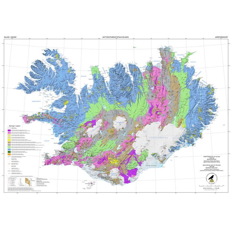
Jarðfræðikorti af Íslandi – Berggrunnur – 1:600.000 [Geological Map of Iceland – Bedrock geology – 1:600.000].
Berggrunnskort af Íslandi sýnir stærstu drættina í jarðfræði landsins. Jarðlög eru flokkuð eftir aldri, gerð og samsetningu. Kortið sýnir vel gosbelti landsins og dreifingu gossstöðva frá nútíma. Nútímahraunum er skipt í forsöguleg og söguleg hraun (yngri en 871 e. Kr. ).
[The Geological Map of Iceland shows the main features of the bedrock geology. Formation are classified by age, type, and composition. The map clearly shows the island's volcanic zones and the distribution of the recent eruption sites. Lava fields of the Holocene are shown as pre-historic or historic (younger than AD 871].]
Simple
- Date (Publication)
- 1989-12-01
- Date (Revision)
- 2014-06-06
- Citation identifier
- {9CA69199-E960-4B6F-AA32-E45A7E04D91D}
- Status
- On going
- Point of contact
-
Organisation name Individual name Electronic mail address Role Náttúrufræðistofnun – Natural Science Institute of Iceland
Point of contact
- Theme
-
-
INSPIRE
-
- Use constraints
- Other restrictions
- Other constraints
-
https://www.natt.is/is/midlun/opin-gogn
Gögnin eru öllum opin – no limitations on public access
- Access constraints
- Other restrictions
- Other constraints
- no limitations to public access
- Spatial representation type
- Vector
- Denominator
- 600000
- Language
- ice
- Topic category
-
- Geoscientific information
))
- Begin date
- 1989-12-01
- End date
- 1989-12-01
- Reference system identifier
- EPSG / 5325
- Distribution format
-
Name Version ESRI ArcGIS FileGDB
10.2.0.3389
ESRI Shapefile
10.2.0.3389
Digital transfer options
- OnLine resource
- Hierarchy level
- Dataset
Conformance result
- Title
-
Commission Regulation (EU) No 1089/2010 of 23 November 2010 implementing Directive 2007/2/EC of the European Parliament and of the Council as regards interoperability of spatial data sets and services
- Date (Publication)
- 2010-12-08
- Explanation
-
Information required according to INSPIRE Geoportal Validator´s verification report. Validation has not been performed.
- Pass
- Yes
- Statement
-
Tekið saman af Hauki Jóhannessyni, en eldri útgáfur af Hauki og Kristjáni Sæmundssyni. Berggrunnskortið var skjáhnitað 1997 eftir skönnun á prentaðri 1. útgáfu frá 1989. Útgáfan var endurskoðuð 1998, 2009 og 2014 miðað við nýjustu upplýsingar um jarðfræði Íslands. Í útgáfu 2014 urðu breytingar á þekju fyrir jarðlög og mislægi. Stuðst var við upplýsingar af jarðfræðikortum 1:250 000, blöð 1-3, 5-7 og 9. Skekkjumörk kortsins eru +/- 500 m. Mælikvarði kortsins var upphaflega 1:500.000 en í útgáfu 2009 var mælikvarða breytt í 1:600.000 og sett sem 1. útgáfa. Gæði gagna eru þau sömu, en útgáfa berggrunnskortsins er eftirfarandi: 1. útgáfu 1989, 2. útgáfu 1998, 1. útgáfa 2009 í mkv. 1:600.000, 2. útgáfa 2014.
Metadata
- File identifier
- {005FFDAD-69A1-4385-B16F-FD31B960FE33} XML
- Metadata language
- English
- Hierarchy level
- Dataset
- Date stamp
- 2025-08-08T13:50:57
- Metadata standard name
-
INSPIRE Metadata Implementing Rules
- Metadata standard version
-
Technical Guidelines based on EN ISO 19115 and EN ISO 19119 (Version 1.2)
- Metadata author
-
Organisation name Individual name Electronic mail address Role Náttúrufræðistofnun – Natural Science Institute of Iceland
Point of contact
)))